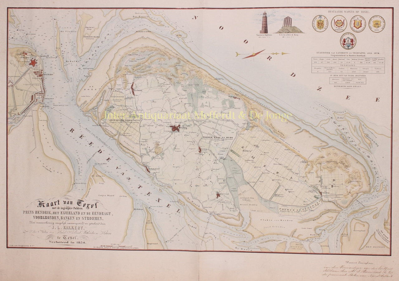
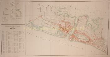
MAP OF TEXEL, UNIQUE PRESENTION EXEMPTION "Map of Texel with the reclaimed Polders Prins Hendrik, het Eijerland en de Eendragt, foregrounds, banks and streams, as accurately as possible composed and drawn by L.J. Kikkert, member of the Staten Noord Holland, Wethouder en Notaris te Texel. Improved in 1854." Lithograph manufactured by Desguerrois & Co. Later hand-coloured. Dim. 58.5 x 82.5 cm. We see the island of Texel and surrounding waters. Names of places and (water) ways, including depth indications are indicated. On the far left the Defence Line of Den Helder. Top right images of the Kijkduin lighthouse, the screen behind de Koog and the coats of arms of Texel. Below that are the statistics for agriculture and livestock on Texel in 1854. The island has a population of "6109 souls". The depths along the coast are indicated in palms. In the 17th and 18th century the Dutch merchant fleets sailed the world seas and a new source of income arose on Texel in Den Hoorn: piloting ships. The importance of this pilot work for the island is shown by the fact that in 1781 Texel had 122 pilots living in Oudeschild, 45 in Nieuwe Schild and 99 in Den Hoorn. In 1783, 1805 ships were piloted on Texel. The Eierlandse Gronden, the water between Texel and Vlieland, was the most dangerous part of the Dutch coast due to the various strong currents which converged there. This regularly resulted in ships getting into difficulties. The Texel notary Johannes Ludovicus Kikkert campaigned for a lighthouse to be built at the northern tip of Texel. The lighthouses of Den Helder and Vlieland were too far apart; it was dark near Eierland. Between 1848 and 1860 no less than 72 ships perished on the Texel coast. Amateur cartographer Kikkert charted the dangerous waters in 1846, 1854 and 1863. Our present copy of the map was presented by Kikkert in 1854 to Mr. J. Heemskerk, member of the Provincial States of North Holland. Beachcombers on Texel were not happy with this call for more light, as they earned a good living from all the shipwrecks. After years of pleading, Kikkert found an audience with the Pilotage for an extra coastal light on the north side of Texel. In 1863, construction of the lighthouse began and the light was lit on 1 November 1864. The pilots' livelihood also came to an end with the construction of the North-Holland Canal (1819 - 1824) and the North Sea Canal (1865 - 1875). Furthermore, in the middle of the 19th century, a national pilot service was established for the sea gate of Texel. A few decades after the end of private pilotage, a number of inhabitants of Den Hoorn and elsewhere found a new source of income: the bulb-growing industry. Price: €2.150